Posts

Fact:1

Image
The  Tehri Dam  is the Highest dam in India and one of the highest in the world. It is a multi-purpose rock and earth-fill  embankment dam on the  Bhagirathi River  near  Tehri  in  Uttarakhand ,  India . 

CHAMPAWAT

Image
Champawat   is a town and a   Nagar Palika Parishad   in   Champawat district   in the state of   Uttarakhand , India. It is the administrative headquarters of Champawat district. The city was the former capital of the   Kumaon Kingdom . Champawat is believed to be the place where the   Kurmavtar   (the turtle incarnation of   Lord Vishnu) took place.These days there is a temple which is called kranteshwar mandir which is dedicated to lord Shiva. It is also believed that the head of Ghatotkacha (son of   Bhima   and the Rakshasi   Hidimbi   ) fell here after he died in battle of   Mahabharata. The Gahtku mandir is the temple dedicated to   Ghatotkacha

BAGESHWAR

Image
Bageshwar   is a city and a   municipal board   in   Bageshwar district   in the state of   Uttarakhand,   India. It is located at a distance of 470 km from the National Capital   New Delhi   and 332 km from the State Capital   Dehradun.Bageshwar is known for its scenic beauty,   Glaciers,   Rivers   and   Temples. It is also the administrative headquarters of   Bageshwar district. Situated on the confluence of   Sarju   and   Gomati rivers,Bageshwar is surrounded by the mountains of Bhileshwar and Nileshwar to its east and west and by the Suraj Kund in the north and Agni Kund in the south. Bageshwar was a major trade mart between   Tibet   and   Kumaun, and was frequented by the   Bhotia   traders, who bartered Tibetan wares,   wool,   salt   and   Boraxin exchange for Carpets and other local produces in Bageshwar.The trade routes were, ho...

ALMORA

Image
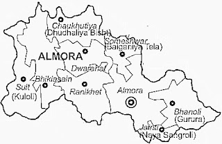
Almora   Hindustani pronunciation   is a   municipal board   and a   cantonment   town in the   Almora district   in the state of Uttarakhand,   India. It is the administrative headquarters of   Almora district.   Almora is located on a ridge at the southern edge of the   Kumaon Hills   of the   Himalaya range, at a distance of 365 km from the   national   capital   New Delhi   and 415 km from the state capital   Dehradun. According to the provisional results of the   2011 national census of India, Almora has a population of 35,513. Nestled within higher peaks of the Himalaya, Almora enjoys a year-round mild temperate climate. Almora was founded in 1568 by King KalyanChand, however there are accounts of human settlements in the hills and surrounding region in the Hindu epic   Mahabharata (8th and 9th century BCE). Almora was the seat of   Chand kings   tha...

MAP OF UTTRAKHAND

Image
DISTRIBUTION-There are 13   districts in Uttarakhand   which are grouped into two divisions, Kumaon and Garhwal. Four new districts named Didihat ,   Kotdwar   Ranikhet , and   Yamunotri   were declared by then Chief Minister of Uttarakhand,   Ramesh Pokhriyal , on 15 August 2011 but yet to be officially formed. Districts of two divisions are as follows: Kumaon Division ·          Almora ·          Bageshwar ·          Champawat ·          Nainital ·          Pithoragarh ·          Udham Singh Nagar Garhwal Division ·          Dehradun ·          Haridwar ·   ...

WELCOME TO UTTRAKHAND

Image
Uttarakhand   officially the   State of Uttarakhand  formerly known as Uttaranchal , is a   state   in the   northern   part of   India . It is often referred to as the   Devbhumi  (literally "Land of the Gods") due to many   Hindu   temples   and pilgrimage centres found throughout the state. Uttarakhand is known for the natural environment of the Himalayas , the   Bhabhar   and the   Terai . On 9 November 2000, Uttarakhand became the 27th state of the   Republic of India , being created from the Himalayan and adjoining northwestern districts of   Uttar Pradesh . It borders   Tibet   to the north; the   Province No. 7   of   Nepal   to the east; and the Indian states of   Uttar Pradesh   to the south and   Himachal Pradesh   to the west and north-west as well as   Haryana   on its south-western corner. The state is divided into two ...